Those of you who follow my content will have noticed that, with some frequency, I relate my adventures with my beloved motorbike along the mythical Ruta 40.
At each stage I try to highlight my most important experiences, despite the fact that some time has passed since this journey began.
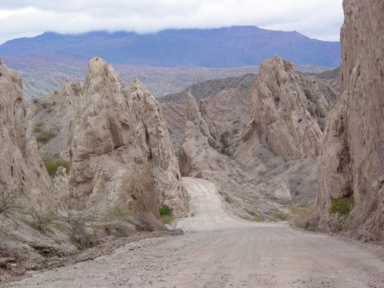
It is a very complex route. Sometimes on asphalt, sometimes on dirt tracks, tracks or simply gravel. You have to manage as best you can, because there is no mechanic's workshop on the roadside. The villages are Andean refuges where time seems to stand still. It is hard enough to find a petrol station.
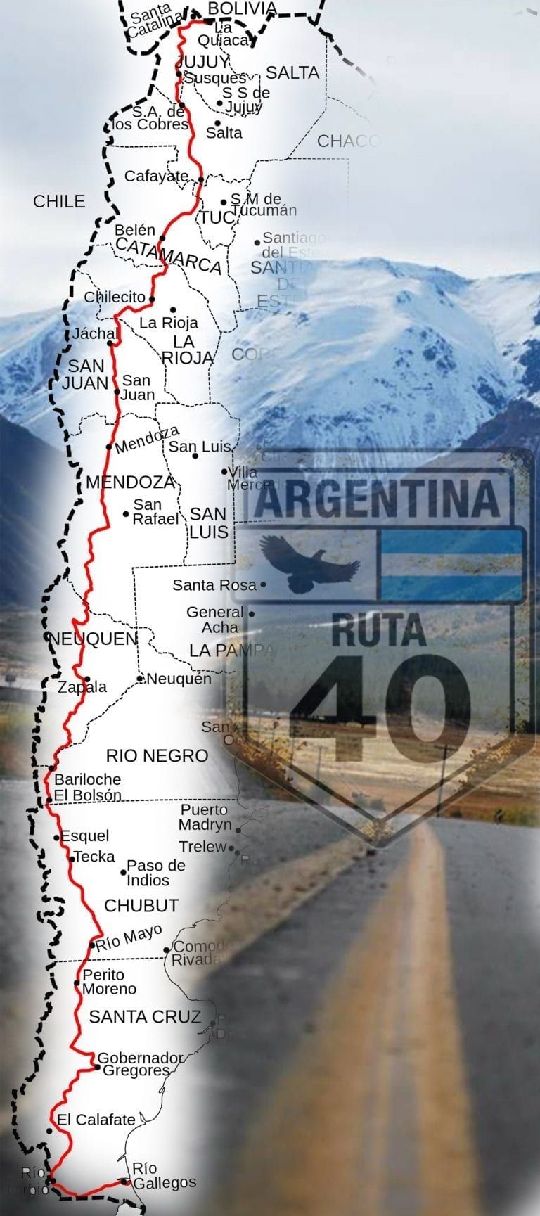
What I have never published are the characteristics of this very long route that crosses and, in a certain way, divides Argentina and Chile from North to South. Although it would be better to say from South to North since it starts at Cabo Virgenes in the southernmost point of the continent, which belongs to the Güer Aike Department of the Province of Santa Cruz in the Argentine Republic.
National Route No. 40 is an Argentinean road that runs from Cabo Virgenes, Santa Cruz to the border with Bolivia in the city of La Quiaca, in Jujuy.
This road runs parallel to the Andes Mountains, including stretches near or through several national parks.
It is the longest in the country, crossing it from south to north, and runs through several of the country's most important tourist regions and attractions.
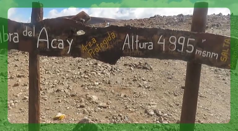
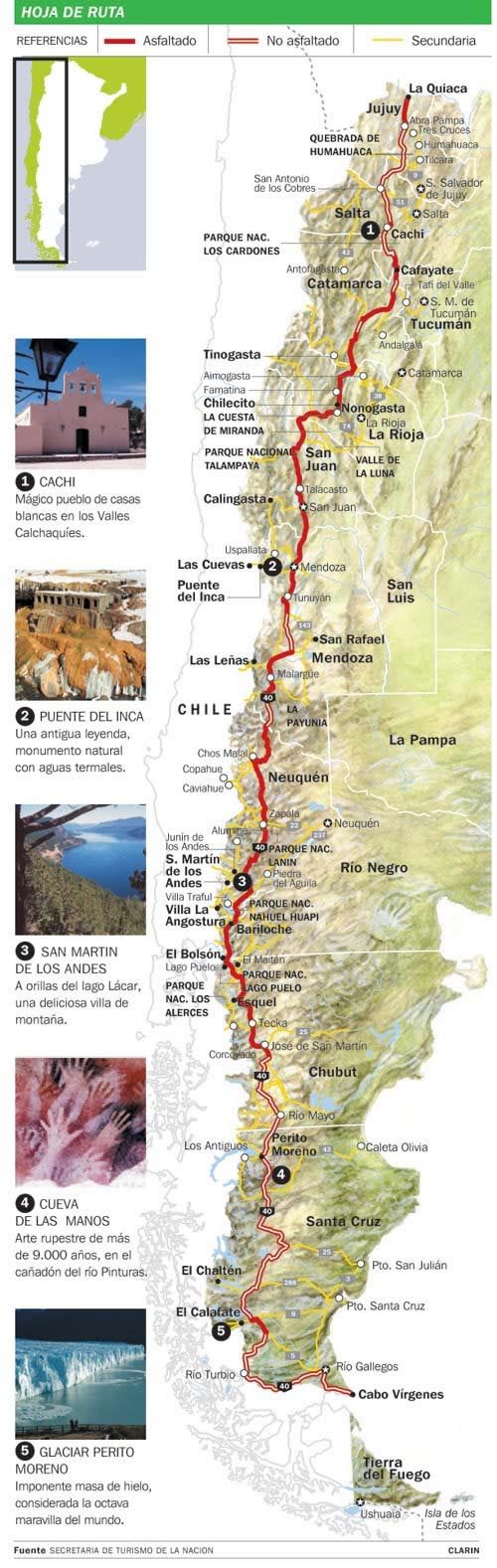
The route is 5224 km long: it starts at sea level, crosses 20 national parks, 18 major rivers, connects 27 mountain passes and climbs to 5000m above sea level at Abra del Acay in Salta.
Like the legendary Route 66 in the USA, Route 40 is an emblem of Argentina. This road crosses 11 provinces: Santa Cruz, Chubut, Río Negro, Neuquén, Mendoza, San Juan, La Rioja, Catamarca, Tucumán, Salta and Jujuy.
This road provides access to El Calafate, near the Perito Moreno Glacier, Lago Puelo, El Bolsón, Bariloche, Chos Malal, the Wine Route in the provinces of Mendoza and San Juan, dinosaur fossil sites in the Province of San Juan, hot springs in Catamarca, the Quilmes Ruins, the Calchaquíes Valleys and the Puna.
Few paving works were done on this road until 2004, when this route was promoted by the Ministry of Tourism as a national tourist product, which allowed more funds to be allocated for the construction of this road. In 2006, Route 40 was 48% paved. Neuquén and Río Negro are the only provinces where the route is fully paved, while in Salta and Jujuy there are few paved stretches.
Since construction began in 1935, the route has changed several times. On 24 November 2004, the Dirección Nacional de Vialidad issued Resolution 1.748/04, which changed the kilometre markers to put the zero at the southern end of the route, at Cabo Vírgenes.
As there is no road built between Cabo Vírgenes and Punta Loyola, the end of the old route, the route begins at km 100. Until then, the road was divided into Ruta 40 South and Ruta 40 North, with kilometre zero originally being at the intersection of Avenida San Martín and Garibaldi Street in the city of Mendoza. Later it was moved to the intersection of Acceso Este (Ruta Nacional 7) and Av. Gob. Ricardo Videla (also known as Avenida Costanera) in the same city.
On May 20, 2005, the Dirección Nacional de Vialidad and its counterpart in Jujuy signed an agreement whereby sections of provincial routes 85, 70, 74, 7, 64, 65 and 5 were transferred to the Nation to build the so-called ‘mining corridor’, which is the new route of National Route 40 further west in the province. This agreement was endorsed by Provincial Law 5520. This changed the name of the road between San Antonio de los Cobres and Abra Pampa to Ruta Nacional 40.

Quienes siguen mis contenidos habrán podido observar que, con cierta frecuencia, relato mis andanzas junto a mi querido moto, por la mítica Ruta 40.
En cada etapa trato de destacar mis vivencias más importantes a pesar de que ya haya transcurrido un cierto tiempo de esta travesía.
Es un recorrido muy complejo. A veces sobre el asfalto, a veces rn mrdio de senteros, huellas o simplemente ripio. Donde te las tienes que arreglar como puedas porque no hay ningún taller mecánico al borde la ruta. Los pueblos son refugios andinos en los cuales el timpo pareciera haberse detenido. Ya es mucho encontrar una gasolinera.
Lo que nunca he publicado son las característica de esta ruta larguísima que atraviesa y, en un cierto modo también divide, Argentina y Chile de Norte a Sur. Aunque seria mejor decir de Sur a Norte ya que comienza en Cabo Virgenes en el extremo austral del continente, que pertenece al Departamento Güer Aike de la Provincia de Santa Cruz en la República Argentina.
La Ruta Nacional n.º 40 es una carretera argentina cuyo recorrido se extiende desde Cabo Vírgenes, Santa Cruz hasta el límite con Bolivia en la ciudad de La Quiaca, en Jujuy.
Esta carretera corre paralela a la Cordillera de los Andes, incluyendo tramos cercanos o a través de varios parques nacionales.
Es la más larga del país, atravesándola de sur a norte y recorre varias de las regiones turísticas y los atractivos más importantes de su territorio.
La ruta recorre 5224 km: comienza a nivel del mar, atraviesa 20 parques nacionales, 18 importantes ríos, conecta 27 pasos cordilleranos y trepa a 5000 msnm en el Abra del Acay en Salta.
Como la legendaria Ruta 66 de EE. UU., la ruta 40 es un emblema de Argentina. Esta carretera cruza 11 provincias: Santa Cruz, Chubut, Río Negro, Neuquén, Mendoza, San Juan, La Rioja, Catamarca, Tucumán, Salta y Jujuy.
A través de esta carretera se puede acceder a El Calafate, cerca del Glaciar Perito Moreno, Lago Puelo, El Bolsón, Bariloche, Chos Malal, la Ruta del Vino en las provincias de Mendoza y San Juan, yacimientos de fósiles de dinosaurios en la Provincia de San Juan, aguas termales en Catamarca, las Ruinas de Quilmes, los Valles Calchaquíes y la Puna.
En este camino se hicieron pocas obras de pavimentación hasta que en el año 2004 esta trayectoria fue impulsada por la Secretaría de Turismo como producto turístico nacional, lo que permitió asignar más fondos para la construcción de esta carretera. En 2006 la ruta 40 estaba pavimentada en un 48%. Neuquén y Río Negro son las únicas provincias donde la ruta está totalmente pavimentada, en tanto que en Salta y Jujuy hay pocos tramos con pavimento.
Desde que se comenzó a construir en 1935 cambió varias veces su recorrido. El 24 de noviembre de 2004 la Dirección Nacional de Vialidad dictó la Resolución 1.748/04, que cambió los mojones kilométricos para poner el cero en el extremo sur del recorrido, en Cabo Vírgenes.
Como no hay camino construido entre Cabo Vírgenes y Punta Loyola, final de la antigua traza, la ruta comienza en el km 100. Hasta ese momento la carretera estaba dividida en Ruta 40 Sur y Ruta 40 Norte, estando originalmente el kilómetro cero en la intersección de la Avenida San Martín y la calle Garibaldi en la ciudad de Mendoza. Luego se trasladó a la intersección del Acceso Este (Ruta Nacional 7) y la Av. Gob. Ricardo Videla (o también Avenida Costanera) de la misma ciudad.
El 20 de mayo de 2005 la Dirección Nacional de Vialidad y su par jujeña firmaron un convenio por el que se traspasan tramos de las rutas provinciales 85, 70, 74, 7, 64, 65 y 5 a la Nación para construir el llamado "corredor minero", que es la nueva traza de la Ruta Nacional 40 más hacia el oeste de la provincia. Este convenio fue refrendado por Ley Provincial 5520. De esta manera se le cambió la denominación del camino entre San Antonio de los Cobres y Abra Pampa a Ruta Nacional 40.
Source background image / Fuente imagen de fondo: Ruta 40.
Sources consulted (my property) for the preparation of this article. Some paragraphs may be reproduced textually.
Fuentes consultadas (de mi propiedad) para la elaboración del presente artículo. Algunos párrafos pueden estar reproducidos textualmente.
| Argentina Discovery. |  |
|---|---|
| Galería Fotográfica de Argentina. |  |
| Viaggio in Argentina. |  |
| Patagonia Express. |  |

Upvoted. Thank You for sending some of your rewards to @null. Get more BLURT:
@ mariuszkarowski/how-to-get-automatic-upvote-from-my-accounts@ blurtbooster/blurt-booster-introduction-rules-and-guidelines-1699999662965@ nalexadre/blurt-nexus-creating-an-affiliate-account-1700008765859@ kryptodenno - win BLURT POWER delegationNote: This bot will not vote on AI-generated content
Thank you @ctime and group of curators for actively participating in this original proposal.