In Victoria, Laguna, it is said that a child suffering from chronic nosebleeds can be cured by submerging his or her head in the waters of Laguna de Bay at sunset. Back in the time when nipa huts where the only form of home construction in the areas surrounding Laguna de Bay, the region’s carpenters would first dip the bamboo used for constructing the houses in the waters of Laguna de Bay as a way of curing them to make them stronger and resistant to termite and wood rot infestation.
But despite of being the undisputed largest lake in the Philippines in terms of total area, why is it that Laguna de Bay has remained largely unknown to tourists both local and foreign alike?
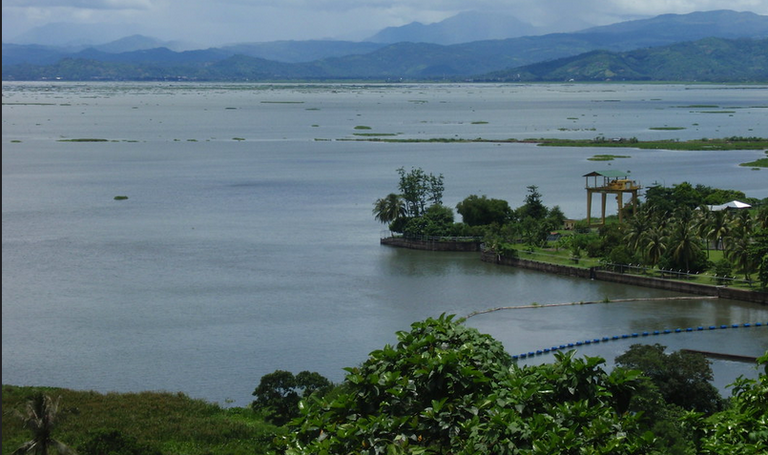
Laguna de Bay means Lagoon of the town of Laguna’s bay for the now lakeshore town of Bay – pronounced as “Bä’I” – the former provincial capital of Laguna province. As a body of water, Laguna de Bay is a large shallow freshwater body in the heart of Luzon Island with an aggregate area of about 911 square kilometers or 352 square miles and a shoreline of 220 kilometers or 140 miles. By way of comparison, Lake Lanao only has an area of 340 square kilometers. Laguna de Bay is considered to be the third largest inland body of water in Southeast Asia after Tonle Sap in Cambodia and Lake Toba in Sumatra, Indonesia. Laguna de Bay is bordered by the province of Laguna in the east, west and southwest, the province of Rizal in the north to northeast and Metro Manila in the northwest. Laguna de Bay has an average depth of 2.8 meters or 9 feet 2 inches and its excess water is discharged through the Pasig River.
It was during the time of the then Philippine President Ferdinand Marcos that Laguna de Bay got brief major press coverage in the wake of signing into law Republic Act (RA) 4850 back in 1966 creating the Laguna Lake Development Authority (LLDA), the main agency tasked to oversee the programs that aims to develop and protect Laguna de Bay even though it only started as a mere quasi-government agency with regulatory and proprietary functions. Its charter was strengthened by Presidential Decree (PD) 817 in 1975 and by Executive Order (EO) 927 in 1983 to include environmental protection and jurisdiction over the surface waters of the lake basin. It wasn’t until 1993 during the administration of then President Fidel V. Ramos that by virtue of devolution that the administrative supervision of the Laguna Lake Development Authority was transferred to the Department of the Environment and Natural Resources (DENR) via Ramos’ Executive Order 149.
Laguna de Bay has been used as a navigation lane for passenger boats since the Spanish Colonial Era that started in 1521. Even though the lake is a multipurpose resource, from a flood preventing diverting water channel for Metro Manila via the Marikina River when diverted via the Manggahan Floodway, the lake remains relatively unknown as a sight-seeing tour site since the 1980s. Even though parts of its shore in the Metro Manila area was decried by local environmental activists since the 1990s over gentrification based over development with no regard to environmental impact studies, a number of the region’s boating sightseeing and fishing tours swear that there are still large parts of Laguna de Bay that remained relatively pristine to the present day, making it still a rewarding tourist destination.
Thank you for using my upvote tool 🙂

Your post has been upvoted (1.47 %)
Delegate more BP for better support and daily BLURT reward 😉
@tomoyan
https://blurtblock.herokuapp.com/blurt/upvote