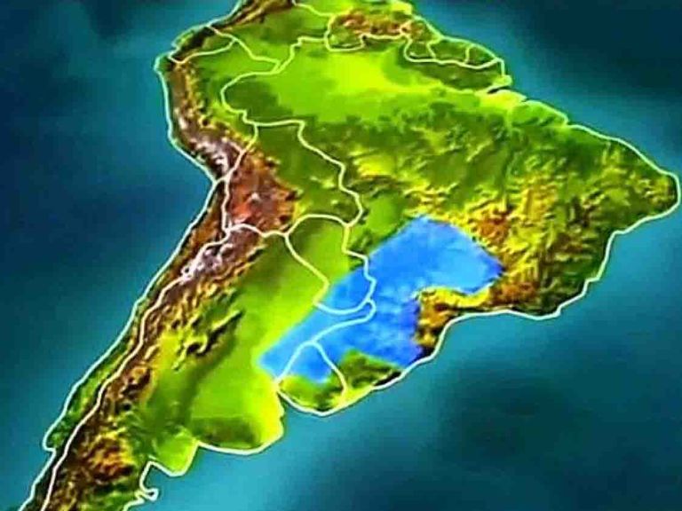
Fresh water represents only 2.5% of the Earth's water, and most of it is frozen in glaciers and ice caps.
Approximately 96% of liquid fresh water is found underground, and the remaining small fraction is found on the surface or in the atmosphere.

El agua dulce representa únicamente el 2,5% del agua de la Tierra y se encuentra en mayor parte congelada en glaciares y casquetes glaciares.
Aproximadamente el 96% del agua dulce en estado líquido se localiza en zonas subterráneas y la pequeña fracción restante se encuentra en la superficie o en la atmósfera.
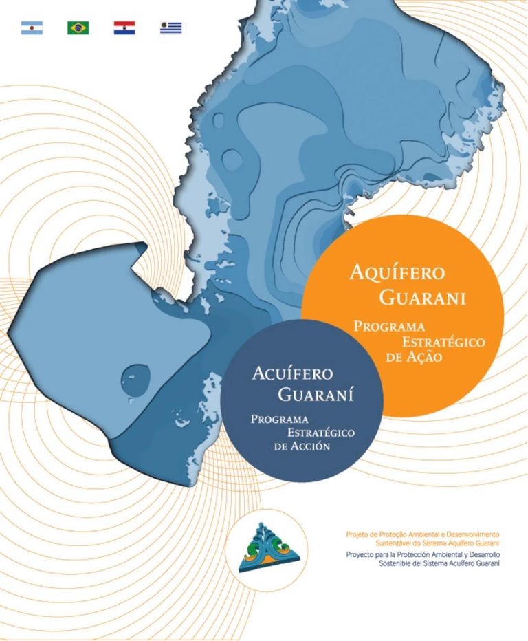
Guarani Aquifer System / Sistema Acuífero Guaraní.
Aquifers are bodies of permeable sediments or rocks that contain exploitable groundwater, which infiltrates and circulates at different speeds (measured in meters per day/month/year), and are connected to the hydrological cycle.
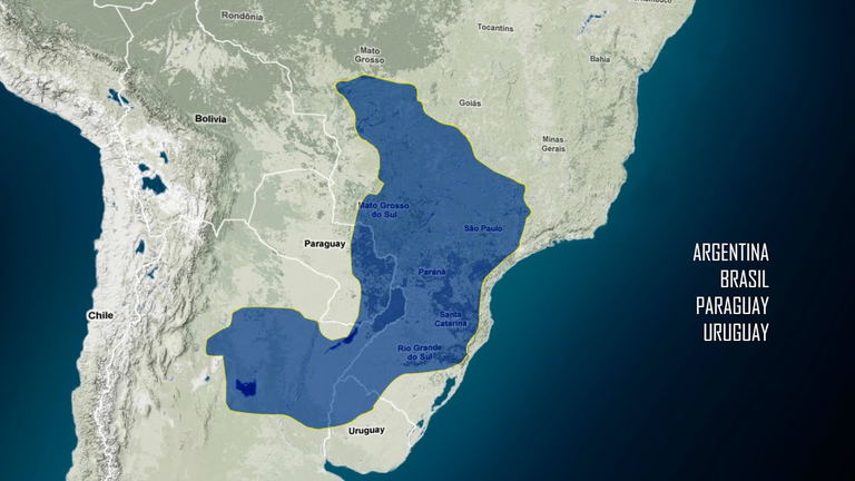
The so-called Guaraní Aquifer System (GAS) is one of the largest underground water reservoirs in the world. It is located between parallels 16º and 32º South and meridians 47º and 60º West, occupying an area of approximately 1,100,000 square kilometers. Its surface coincides with part of the Plata river basin, extending from the geological-sedimentary basin of the Paraná to the Chacoparanaense basin.
The current climate of the SAG region is characterized as humid or sub-humid with annual rainfall of 1200 to 1500 mm. Water balances have shown that in most of the area there is an annual surplus of at least 300 mm, reaching up to 600 mm in the southern region (Paraguay, Argentina and Rio Grande do Sul). This surplus runs off the land surface and part of it also feeds the aquifers.
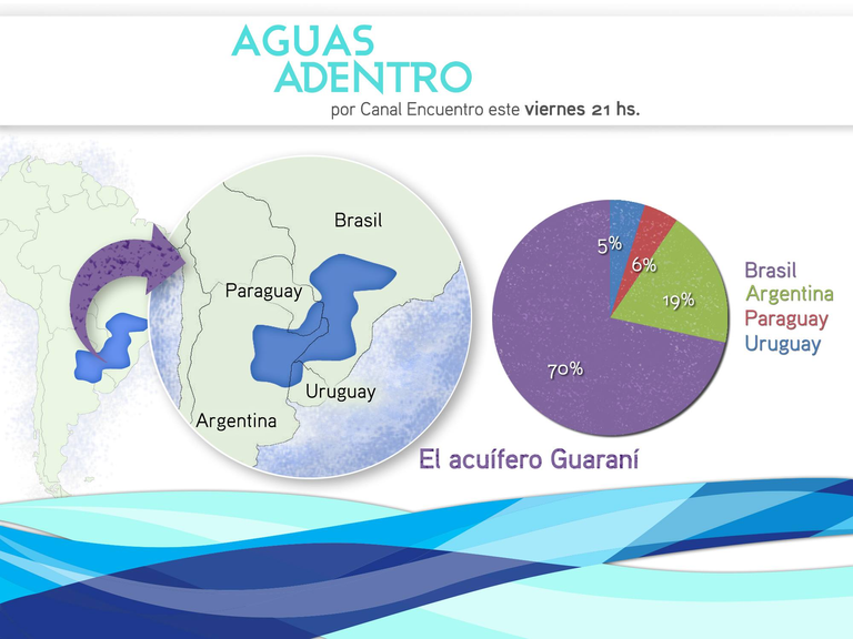
The SAG area is covered by approximately 1,500 municipalities belonging to four countries: Argentina, Brazil, Paraguay and Uruguay. The population of the area amounts to 23,500,000 inhabitants, of which approximately 9,000,000 are supplied by the aquifer. The water is used mainly for human and industrial purposes, and to a lesser extent for exploitation such as thermal baths. The country that uses it the most is Brazil: there the SAG supplies between 300 and 500 cities.

Los acuíferos son cuerpos de sedimentos o rocas permeables que contienen agua subterránea explotable, que se infiltra y circula con diferentes velocidades (medidas en metros por día /mes/ año), y están conectados al ciclo hidrológico.
El denominado Sistema Acuífero Guaraní (SAG) es uno de los reservorios de agua subterránea más grandes del mundo. Se encuentra localizado entre los paralelos 16º y 32º Sur y los meridianos 47º y 60º Oeste, ocupando un área de alrededor de 1.100.000 kilómetros cuadrados. Su superficie coincide con parte de la cuenca hidrográfica del Plata, extendiéndose desde la cuenca geológico- sedimentaria del Paraná hasta la cuenca Chacoparanaense.
El clima actual de la región del SAG se caracteriza como húmedo o sub- húmedo con precipitaciones anuales 1200 a 1500 mm. Los balances hídricos han mostrado que en la mayor parte del área existe un excedente anual de al menos 300 mm, llegando hasta los 600 mm en la región Sur (Paraguay, Argentina y Rio Grande do Sul). Ese excedente es el que es- curre sobre la superficie terrestre y parte también alimenta los acuíferos.
Por sobre el área del SAG se ubican alrededor de 1.500 municipios pertenecientes a cuatro países: Argentina, Brasil, Paraguay y Uruguay. La población del área asciende a 23.500.000 habitantes, de los cuales unos 9.000.000 se abastecen del acuífero. El agua es utilizada principalmente para la provisión humana y de industrias, y en menor grado para explotación como termas. El país que más lo utiliza es Brasil: allí el SAG abastece entre 300 y 500 ciudades.
Geology and Hydrogeology of SAG / Geología e Hidrogeología del SAG.
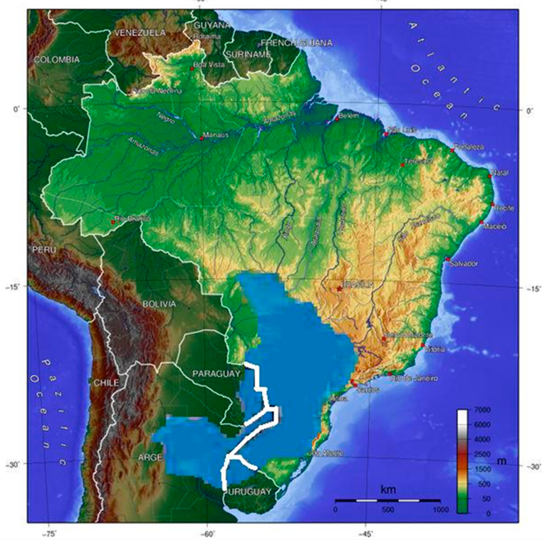
The Paraná Basin (and the Chacoparanaense included in it) is a geological basin located between two very old stable continental cratons or areas. It occupies an enormous extension: from Goias, in Brazil, to the north of Uruguay and from São Paulo to eastern Paraguay; its SW edge is limited by the Pampas mountains of Argentina (Figure 1). This large basin contributed porous and permeable sandy bodies both on its sides and in the centre of the basin.
Above it, and through a regional discordance, there is distributed throughout the region an almost continuous layer of mainly aeolian sandstones, of Juro-Cretaceous age, which is the main reservoir where the waters of the Guarani Aquifer are housed.
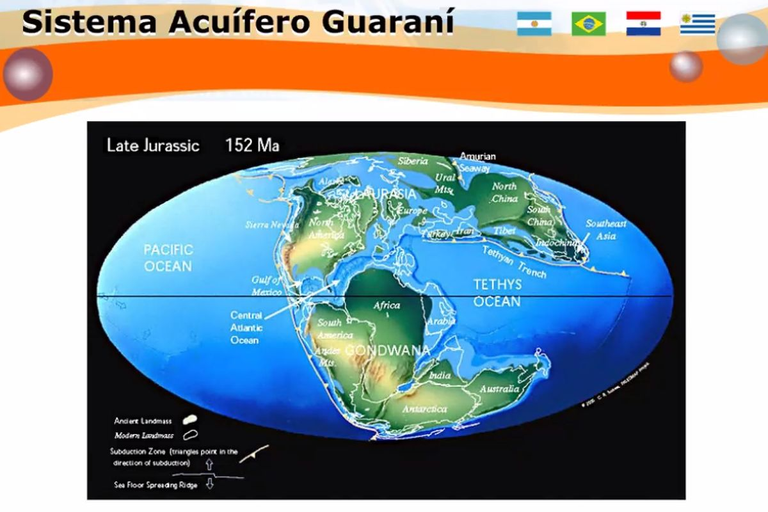
All this variety of sandy deposits, some distributed locally, others regionally, have been covered by a thick and extensive cover of Cretaceous volcanic flows called Serra Geral Formation, concomitant with the separation of continents and the formation of the Atlantic Ocean. Within the vulcanites, intercalated eolian sandy deposits are recognized, which were preserved within the volcanic field. These intercalations may be local water reservoirs and are known as intertraps or Solari Formation in Argentina.
The Guarani Aquifer System is one of the largest groundwater reservoirs in the world and occupies an area of around 1,100,000 square kilometers.
The Ponta Grossa Arch, in the Brazilian state of Paraná, is a deep geological structure (along the arches the oldest rocks are found closer to the ground surface), associated with a significant number of NW-oriented dikes and basic layer veins, also having a general impact on the behavior of the groundwater flow in the SAG. On the other hand, the Rio Grande-Asunción Arch, which was then outcropping, originated the north-south division of the Jurassic sedimentary basin in which the SAG is located today.
Laboratory geological and petrological studies have allowed the different sedimentary units attributable to the Guaraní to be characterized and correlated in the four countries. The frequency distribution of the samples analyzed indicates a similarity in the behavior between the Botucatú, Misiones and Tacuarembó formations (which are the different names assigned to the geological units of the SAG, in Brazil, Argentina and Paraguay, and Uruguay, respectively), which has also been confirmed in their mineralogical characterization. In addition, it has been shown that this large regional and prebasaltic sandy unit was formed in the same type of eolian sedimentation environment – a large desert – with fluvio-eolian sectors interspersed that indicate the few places where river courses ran. In the southern region of the SAG, where data have been taken, the direction roses indicate that the predominant paleowinds blew from the SW quadrant towards the NE during the deposition of the sediments and formed dunes of various types.
The SAG is therefore geologically related to sandstone layers that were deposited during the Mesozoic (from the Triassic to the Early Cretaceous) with ages between 200 and 132 million years. The sandy unit reached thicknesses of up to 800 m. The greatest thicknesses (more than 500 m) occur mainly along a NNE-SSW axis, subparallel to the current Paraná and Uruguay rivers and almost concordant with the depositional axis of the Paraná geological basin. In turn, the greatest thicknesses of the post-SAG rocks and sediments, that is, the roof that covers it, are up to 1900 m, with values between 1400 and 1000 m being more frequent in the deepest sectors of the SAG. The sandstones outcrop only in 10% of the total surface, with the rest of the SAG being beneath it at different depths.
The geothermal sectors of the Guaraní aquifer –geological basins of Paraná and Chaco-Paranaense– acquire their temperature due to the transfer of natural heat from the earth's crust, which increases according to the average global geothermal gradient of 3.3ºC for every 100 meters of depth. Consequently, the water that infiltrates from the surface increases its temperature as it goes deeper into the aquifer.
The regional hydrogeological map, and its interpretation or conceptual model, allowed the establishment of the design of a flow system, in which four large hydrodynamic areas are recognized that indicate the movement of groundwater.
The predominant types of water, depending on whether they are at the surface or deep, are bicarbonate, calcium, sodium and chloride-sulphate-sodium bicarbonate. Isotopic studies determined that the SAG waters would have been recharged under more humid and cold conditions than those at present, and C14 dating indicates recharges from an older period of 35,000 to 40,000 years for these waters, during the last glaciation, with even older ages being possible.
Regarding a possible discharge from the Guaraní aquifer to the wetlands of Esteros del Iberá, Corrientes Province, the results of hydrochemical and isotopic data (especially tritium) have initially, and until now, ruled out this hypothesis. In Argentina, hydrochemical and isotopic studies and research are still being carried out in wetlands and rivers by means of the International Atomic Energy Agency, recharge and discharge areas, and numerical simulation through Universities: such as UNL and UNCentro; the Argentine National Agency for Scientific Promotion and the Ministry of Science of Spain, among others.

SAG Water Uses and Reserves / Geología e Hidrogeología del SAG.
In the Paraná River basin, the average annual water availability (excesses) varies between 350 and 400 mm, while the average annual deficits show values between 150 and 220 mm. The highest magnitudes of average annual surface water availability are recorded in the Iguazú and Uruguay River basins with values between 500-650 mm, while the average annual deficits do not exceed 90 mm.
The total volume of water in the aquifer is 30,000 km3, although the exploitable reserves are within 2,000 km3. The general recharge of the SAG in the outcropping sectors of the four countries is only 5 km3/year. For comparison, let us consider that the approximate module of the Paraná River is 80 km3/year.
Brazil is the country that exploits the resources supplied by the SAG the most, with 93% of the volume extracted per year, consuming almost 1 km3/year (one billion liters). Public supply is the main destination of the water resource captured by wells in the SAG area, while in Argentina, exploitation in thermal centers has also gained importance.
In order to evaluate the impact of the dynamics of human occupation in the area, the results of multisequential land use maps were analyzed using satellite images. The classes that showed the greatest changes were the forests, which went from occupying 42% of the surface of the Aquifer in the 1970s to only 8% today.
The uncertainties of climate change models present different future scenarios for the Guaraní region. The most unfavorable assumes a global average temperature increase of 3°C by 2080. In that case, the availability of water in the soil would be substantially reduced annually in the northwestern area of the SAG, where the deficits would increase markedly, especially affecting the area of Paraguayan and Brazilian territory between 15º and 20º S and between 49º and 57º W.

La del Paraná (y la Chacoparanaense incluida en ella) es una cuenca geológica, ubicada entre dos cratones o áreas continentales estables muy antiguas. Ocupa una enorme extensión: desde Goias, en Brasil, hasta el norte del Uruguay y desde San Pablo hasta el Paraguay oriental; su borde SO tiene como límite las sierras pampeanas de Argentina (Figura 1). Esta gran cuenca aportó cuerpos arenosos porosos y permeables tanto en sus flancos como en el centro de la cuenca.
Por encima de la misma, y mediando una discordancia regional, se distribuye en toda la región un manto casi continuo de areniscas principalmente eólicas, de edad juro-cretácica, que es el principal reservorio, donde se alojan las aguas del Acuífero Guaraní.
Toda esta variedad de depósitos arenosos, distribuidos algunos local- mente, otros regionalmente, han sido cubiertos por una espesa y extensa cobertura de coladas volcánicas del Cretácico denominada Formación Serra Geral, concomitantes con la se- paración de continentes y formación del océano Atlántico. Dentro de las vulcanitas se reconocen intercalados depósitos arenosos eólicos que se preservaron dentro del campo volcánico. Estas intercalaciones pueden ser reservorios locales de agua y se los conoce como intertraps o Formación Solari en la Argentina.
El Sistema Acuífero Guaraní es uno de los reservorios de agua subterránea más grandes del mundo y ocupa un área de alrededor de 1.100.000 kilómetros cuadrados.
El Arco de Ponta Grossa, en el estado brasileño de Paraná, es una estructura geológica profunda (a lo largo de los arcos las rocas más antiguas se hallan más cerca de la superficie del terreno), asociada a importantes cantidad de diques y filones capa básicos con orientación NO, teniendo también incidencia general en el comportamiento del flujo de las aguas subterráneas del SAG. Por otro lado, el Arco Río Grande- Asunción, que entonces afloraba, originó la división norte-sur de la cuenca sedimentaria jurásica en la que hoy se encuentra alojado el SAG.
Los estudios geológicos y petrológicos de laboratorio han permitido caracterizar y correlacionar las distintas unidades sedimentarias atribuibles al Guaraní en los cuatro países. La distribución de frecuencia de las muestras analizadas indica una similitud en el comportamiento entre las formaciones Botucatú, Misiones y Tacuarembó (que son los diferentes nombres asignados a las unidades geológicas del SAG, en Brasil, Argentina y Paraguay, y Uruguay, respectivamente), lo que ha sido también confirmado en su caracterización mineralógica. Además, se ha demostrado que esta gran unidad arenosa regional y prebasáltica se ha formado en un mismo tipo de ambiente de sedimentación eólico –un gran desierto– con sectores interca- lados fluvio-eólicos que señalan los escasos lugares por donde corrían cursos fluviales. En la región sur del SAG, donde se han tomado datos, las rosas de direcciones indican que los paleovientos predominantes soplaban desde el cuadrante SO hacia el NE durante la deposición de los sedimentos y conformaron dunas de variado tipo.
El SAG, entonces, está relacionado geológicamente a camadas de areniscas que se han depositado durante el Mesozoico (desde el Triásico hasta el Cretácico inferior) con edades entre 200 y 132 millones de años. La unidad arenosa alcanzó espesores de hasta 800 m. Los mayores espesores (más de 500 m, ocurren principalmente a lo largo de un eje NNE-SSO, subparalelo a los actuales ríos Paraná y Uruguay y casi concordante con el eje deposicional de la cuenca geológica de Paraná. A su vez, los mayores espesores de las rocas y sedimentos post SAG, o sea el techo que lo cubre, son de hasta 1900 m, siendo más frecuentes valores entre los 1400 y 1000 m en los sectores más profundos del SAG. Las areniscas afloran sólo en un 10% de la superficie total, estando el resto del SAG bajo la misma a diferentes profundidades.
Los sectores geotermales del acuífero Guaraní –cuencas geológicas de Paraná y Chaco paranaense– adquieren su temperatura debido a la transferencia del calor natural de la corteza terrestre, que aumenta según el gradiente geotérmico promedio mundial de 3,3ºC cada 100 metros de profundidad. En consecuencia, el agua que se infiltra desde la superficie va aumentando su temperatura a medida que se profundiza en el acuífero.
El mapa hidrogeológico regional, y su interpretación o modelo conceptual, permitió establecer el diseño de un sistema de flujo, en el que se re- conocen cuatro grandes áreas hidrodinámicas que indican el movimiento del agua subterránea.
Los tipos de agua predominantes, y de acuerdo si están aflorando y profundas, son de tipo bicarbonatadas, cálcicas, sódicas y bicarbonatada clorurada-sulfatada-sódica. Los estudios isotópicos determinaron que las aguas del SAG habrían sido recargadas en condiciones más hú- medas y frías que las actuales y las dataciones con C14 indican recargas de una época más antigua de 35.000 a 40.000 años para estas aguas, durante la última glaciación, siendo posibles edades más antiguas aún.
En relación con una posible descarga del acuífero Guaraní a los humedales de los Esteros del Iberá, Provincia de Corrientes, los resultados de datos hidroquímicos e isotópicos (especialmente tritio) en principio, y hasta ahora, descartaron esta hipótesis. En la Argentina se continúan realizando estudios e investigaciones hidroquímicas e isotópicas en humedales y ríos por medio de la Agencia Internacional de Energía Atómica, áreas de recarga y descarga, y de simulación numérica a través de Universidades: como la UNL y UNCentro; Agencia Nacional de Promoción Científica Argentina y Ministerio de Ciencia de España, entre otros.
Threats and Risks in SAG / Amenazas y Riesgos en el SAG.
Some SAG sectors are at risk, mainly due to:
Overexploitation, that is, extraction of a quantity of water greater than the aquifer permanently replenishes.
Pollution: result of poor construction of wells and/or the lack of water and waste treatment systems due to industrial discharges in recharge areas (both domestic waste liquids and agrochemicals and insecticides in rural areas).
Detailed studies and numerical models carried out in four pilot studies have allowed future scenarios to be simulated with increased exploitation or changes in well locations. Decreases (loss of hydrostatic pressure) have been determined, as well as extensions based on the simulation of the levels of groundwater that interfere with each other (due to the influence between the wells), and even a decrease in temperature in hot springs. A regional model indicates, for a 100-year scenario of the SAG, that beyond 300 km of distance no effect of exploitation would be detected. In addition, the western edge of the SAG outcrop is a region of local recharge and of both regional and local discharge. The simulations would also indicate that the stretches of numerous surface courses in outcrop areas could be discharge routes for the aquifer, at least at the shallowest levels, reducing deep recharge.

Sobreexplotación, es decir, extracción de una cantidad de agua superior a la que el acuífero repone permanentemente.
Contaminación: resultado de la deficiente construcción de perforaciones y/o la carencia de sistemas de tratamiento de aguas y residuos por vertidos industriales en áreas de recarga (tanto líquidos residuales domésticos como agroquímicos e insecticidas en zonas rurales).
Los estudios de detalle y modelos numéricos realizados en cuatro estudios piloto, permitieron simular escenarios futuros con mayores explotaciones o cambios de ubicación de pozos. Se han determinado descensos (pérdida de presión hidrostática), extensiones basados en la simulación de los niveles del agua subterránea interferidos entre sí (por influencia entre los pozos), e incluso disminución de temperatura en termas. Un modelo regional indica, para un escenario de cien años del SAG, que más allá de los 300 km de distancia no se detectaría efecto alguno de explotaciones. Además, el borde occidental de afloramiento del SAG es una región de recarga local y de descarga tanto regional como local. Las simulaciones indicarían también que los tramos de numerosos cursos superficiales en zonas de afloramiento podrían ser vías de descarga del acuífero, al menos de los niveles más someros, reduciendo la recarga profunda.
Conclusion / Conslusión.
What was initially suggested hydrogeologically at a regional scale as a single basin with a single large reservoir and a single basaltic mantle, and very little deformed, becomes more complex in the light of new knowledge with frequent heterogeneities, especially when it is considered and studied in greater detail.
At a more local level, studies are therefore needed at least on a scale of 1:50,000, or at most 1:100,000, to define the most precise scope of interferences, flow connections and greater risks of contamination transmission, among other problems. This also entails the application of more proven and specialized techniques and interdisciplinary work that goes beyond the mere professional activity of individual intervention or consultancy to solve problems in the SAG.

Lo que a escala regional, en principio, se insinuaba hidrogeológicamente como una única cuenca con un solo gran reservorio y un manto basáltico único, y muy poco deformada. A la luz de los nuevos conocimientos se complejiza con frecuentes heterogeneidades, especialmente cuando se la considera y estudia con mayor detalle.
A nivel más local, entonces, son necesarios estudios al menos en escala 1: 50 000, o a lo sumo 1:100 000, para definir los alcances más precisos de las interferencias, conexión de flujos y mayores riesgos de transmisión de contaminación, entre otras problemáticas. Esto conlleva, además, la aplicación de técnicas más probadas y especializadas y un trabajo interdisciplinario que supera la mera actividad profesional de intervención o consultoría individual para resolver problemáticas en el SAG
Source images / Fuente imágenes.
| Blogs, Sitios Web y Redes Sociales / Blogs, Webs & Social Networks | Plataformas de Contenidos/ Contents Platforms |
|---|---|
| Mi Blog / My Blog | Los Apuntes de Tux |
| Mi Blog / My Blog | El Mundo de Ubuntu |
| Mi Blog / My Blog | Nel Regno di Linux |
| Mi Blog / My Blog | Linuxlandit & The Conqueror Worm |
| Mi Blog / My Blog | Pianeta Ubuntu |
| Mi Blog / My Blog | Re Ubuntu |
| Mi Blog / My Blog | Nel Regno di Ubuntu |
| Red Social Twitter / Twitter Social Network | @hugorep |

| Blurt Official | Blurt.one | BeBlurt | Blurt Buzz |
|---|---|---|---|
 |  |  |  |
 |  |  |  |
|---|

Upvoted. Thank You for sending some of your rewards to @null. Get more BLURT:
@ mariuszkarowski/how-to-get-automatic-upvote-from-my-accounts@ blurtbooster/blurt-booster-introduction-rules-and-guidelines-1699999662965@ nalexadre/blurt-nexus-creating-an-affiliate-account-1700008765859@ kryptodenno - win BLURT POWER delegationNote: This bot will not vote on AI-generated content
Thanks!