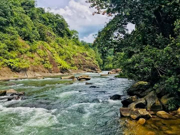
Ruins hidden in the Sitawaka Ganga, the main tributary of the Kelani
The Seethawaka River originates from the hills of the Udamaliboda Butterfly Site. It is the main branch that joins the Kelani River in the valley below. The Sitaka river flows through the narrow and beautiful valley covered by the mountain slopes.
There are many unknown ancient monuments related to Sita's kingdom period located in the lower valley of this river. Among them, we are taking this step to find out about some of the ancient remains in the river valley.
Sitaka river
The headwaters of Seethawaka Ganga originate from the high mountains of Dikhallakande, which is about 20 kilometers away from Udamaliboda from Deraniyagala. The mountains of this place are about 5000-5500 feet high. These hills are connected to the Butterfly Range. This river is known as Magal Ganga in Udamaliboda - Deraniyagala areas.
Avissawella - Nuwara Eliya A7 road from Avissawella town towards Yatianthota, we meet Sitawaka River on the edge of the road. There is also a bridge built across this river in Taldu.
Many tributaries join this river above Deraniyagala. They are Yaye Ganga, Halathure Ganga, Mondagal Oya, Kadiran Oya, Panakure Oya, Miyanavithi Oya, Kamburugam Oya. Seethawaka River joins the Kelani River in Kudagama, three kilometers north of Avissawella.
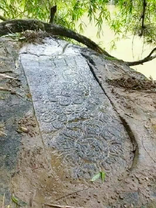
Rampadagala Siripatula
The Avissawella Karavanella road leads to Dehiowita along the banks of the Sitawaka River. The village called Pitadenia is located at a distance of 7 kilometers from Avissawella. The road leading to the south near the Pitadenia Bodhi tree has fallen to the village of Thimbiripola. When we walk a kilometer on that road, we can see the Sangili Bridge across the Seethawaka River.
When you walk another 300 meters to the left among the bushes near the bridge, you can see the Siripatul logo engraved on a rock on the river bank. This place belongs to Dehiovita Divisional Secretariat Division, Atulugam Korale, Kegalle District. This 20 feet high rock is located in a ground full of thickets next to the river.
It is called "Rampadagala Siripatula". There is no specific road to reach the place of Siripatula. Below this rock, the river flows through the valleys creating a beautiful view. The siripatula is 4 feet long and has been created by slightly digging out the rock. Width is one and a half feet. Toes are about 10 inches long.
The central space of the Sripada mark is decorated with six circular lotus flower marks. They are 8, 10, 12 inches in diameter. It is designed as if there are eight petals of a lotus flower. Small petals have been created on the main petals. The engraver has tried to engrave the wedding marks that should be on a Buddha statue and here the skill of the engraver is also clear to us. There are also evidences that there was a lamp post nearby.
Pits dug near the Siripa mark on the rock indicate that there was a piyassa on pillars above the Siripatula. According to the legend woven around Siripatula, this was done by King Rajasingha of Sita. When King Rajasingha's queen was about to have a child, due to the grief that arose, she wanted to worship Sripada.
At that time, the kingdom was attacked by enemies and the surrounding area was insecure, so it was not possible to accomplish that task. It is said that because of this, the king Sita has created a siripatula in this stone rock on the bank of the river to facilitate the worship of the goddess Sripada from the palace.
After crossing the Seethawaka river from the Sangili Bridge at Rampadagala Siripatula, we will enter the Timbiripola village. About seventy-five families live in this remote village. Rajalena is found after going about one kilometer towards the mountain from the middle of Timbiripola village.
In 1952 Professor Senarath Paranavithana came and explored Raja Lena, a fact said by the elders of the village. The inscriptions inscribed here show that the surrounding mountain region has been inhabited since the 2nd century BC. It has also been mentioned that those caves were made and offered to the Sangha.
Kanamadiriyan Vara (Kanamadiri Vakkalama)
The station which was known as Kanamadiri Vakkalama then was later populated as Kanamadiri Wala and to reach this Kanamadiri pit, one has to travel about 600 meters on the Avissawella Panawala road that turns from Taldu. Then the river of Sita is seen flowing. Here the river bends at an angle of 45 degrees and flows down. On the hill on the left is the palace grounds of Sita. The name of Kanmadiriyan bhara is given to a deep place located near a narrow bend on the other bank of the river. The Ritigaha stream joins the Seethaka river here.
There is a deep bend in the river. The Bhairandi temple is located above the river bank. There is a large rock at the bottom of the river at the location of this dam, and a pit has been dug in the middle of it. It is difficult to see the rock at the bottom because of the water in the river, and it is said that it emerges during the dry season when the water is very low.
The length and width of the quarry varies and the depth is uneven from place to place. The section on the Bhairandi temple side is 52 feet long and observations have revealed that the rock is located in such a way that it goes deep from the cutting opening.
#krsuccess #blurt #geekpranee #song #average #life #space #toilet
Dear @praneeth123, your content was selected manually by curators @nalexadre, @ten-years-before to receive a curation from BeBlurt 🎉