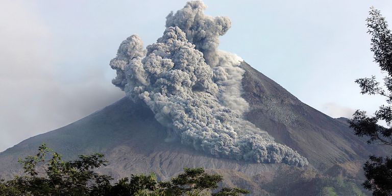
Head of the Geological Agency of the Ministry of Energy and Mineral Resources (ESDM) Eko Budi Lelono said the Anak Krakatau volcano was currently still on an alert status. The Center for Volcanology and Geological Hazard Mitigation (PVMBG) team continues to evaluate the data thoroughly to estimate the potential threats that exist in the future.
"There is no need for a status increase," said Eko during a virtual press conference, Wednesday (9/2).
Eko explained, whether there is a connection between the activity of Anak Krakatau volcano and the earthquake that occurred some time ago in Banten, it is necessary to analyze the data first. However, his side saw that based on monitoring data, it showed that overpressure on Mount Anak Krakatau had occurred before the Banten earthquake.
He said, Mount Anak Krakatau is characteristically identical to Mount Honga Tonga in the Tonga Islands which caused the tsunami in January. However, Eko explained, based on monitoring data, the possibility of this happening on Mount Anak Krakatau is very small for several reasons.
The first is because the volume of magma intrusion at Mount Anak Krakatau is currently not large, which is indicated by seismic, deformation, and SO2 gas content. And the second is that the peak height of Mount Anak Krakatau is currently less than 100 meters, while in 2018 the peak height exceeded 300 meters and due to slope instability, it experienced a landslide or collapsed.
In dealing with the eruption of Mount Anak Krakatau, Eko said the Geological Agency had taken several steps. Namely, by sending an Emergency Response Team to evaluate the data comprehensively. Then coordinate with BMKG and BPBD related to strengthening monitoring of Mount Anak Krakatau, analysis of potential landslides and strengthening of the tsunami early warning system.
"We suggest placing tide gauges and buoys on the nearby island of Mount Anak Krakatau, so that information on the potential for a tsunami can be known before the tsunami waves reach the coast," said Eko.
On the same occasion, Head of PVMBG, Geological Agency of the Ministry of Energy and Mineral Resources Andiani said, the Geological Agency is committed to providing the best and excellent service to the community. Monitoring of Mount Anak Krakatau is carried out for a full 24 hours.
"Of course, all changes physically, as well as instruments or chemically will be conveyed to the public." he said.
Andiani said, to get the latest information about geological disasters, the public can download the Magma Indonesia application. "Because this application is very useful for knowing real-time disaster conditions, including volcanic disasters," concluded Andiani.