In a video documentary broadcast by the BBC, it was revealed that there is an isolated village at an altitude of about 7000 feet in the mountains of Sri Lanka, and the people living there do not have many facilities. A Sri Lankan TV channel also reported about this in relation to this BBC Video program.
Accordingly, the then chief minister of Sabaragamuwa province, who invited me, asked me about this. I explained that this is not an ordinary village, but a place where the houses of the plantation workers are controlled by a plantation company, and that the company called Vatu Manawa Vavili Trust is in charge of its health affairs and works together with the respective plantation company.
But I was appointed to inspect this village and submit a report. I was also instructed to take provincial journalists with me.
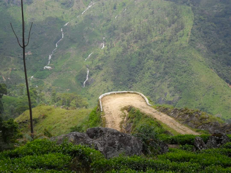
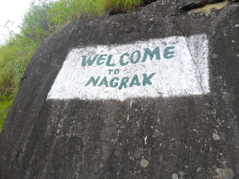
The highest part of Non Peril tea plantation located in Ratnapura district, Belihul Oya area (height 2100 feet above sea level) is called Nagrak (height 6990-7000 feet above sea level). This is the second highest village in Sri Lanka (the first place is Shantipura in Nuwara Eliya). 7300 feet above the level) Nagrak village belonged to the administrative division known as Haputale Pahala District during the British rule.
When going from Balangoda to Belihul Oya (Badulla Road), we started the journey by turning left at the Non Peril intersection.
I have never seen such a difficult plantation road in my life. Total climb is about 5000 feet. The most difficult thing is that there are 23 hair-pin bends on the 20-kilometer estate road. Because of the heavy rain, the water flows down from the top of the mountain have dug holes everywhere on the road. Even though the vehicle we traveled was a 4WD, we had to travel very slowly with tires and stones. On one side is the great mountain. On the other side is the great cliff of hundreds of feet. If there is a slight delay error, all of us along with the vehicle will fall into that great cliff into piles of bodies. On that road where only one vehicle could go, the biggest problem was driving the vehicle through the elbow bends. Had to reverse at least twice and climb out of the vehicle through the elbow bend very carefully.
A bus plies three times a day on Nagrak road, only 2 km from the beginning of the road. It is also near the Vivegananda Tamil College which was the only school in the Non Peril Estate. After that, the width of the road decreases and the ascent becomes tougher. No other vehicles except a small 4WD
Two elbow bends on this mountain road are important places. Bakers Bend (elbow bend number 23) located at a height of 5200 feet is a very amazing creation. One who travels up the road coming from the bottom feels that the road stretches up to the sky. The British planter Samuel Baker, who built this road in a very creative way, from the bottom of the great cliff, walled with big black stones, created an elbow bend there, turned the road towards the other mountain and directed it to go up from there (no mechanical equipment). It was built entirely by the labor of laborers at that time when there was no
The 18th bend is important because of the people who jump down from Worlds End to commit suicide. Those dead bodies fall to Pudukadu, which is part of this plantation, which is more than 2000 feet below. As .Plant workers comb the mountains to find such body parts and chew them and charge a lot of money. A black-painted tin shed has been built at the foot of the hill in Pudukadu section to house the dead bodies, and the post-mortems are conducted there, and the dead bodies are brought to the main road through the elbow bend number 18.
The life of these plantation workers living at a height of 7000 feet is very sad. About 200 years ago, they descended from Indian plantation workers who came from the Nilgiri mountain range of South India (from the area known as "Ooty" today), and intermarriage also takes place only among them (there is little contact with those from the lower parts of the estate. The difficulty of the road greatly affects it.) Because of the mountain tops, there are very strong wind currents in this area. To prevent the roofs of their lime rooms from blowing away in the wind, stones and logs are used for the roof, but they say it is often not enough.
And a specialty of Nagrak village is the ever-changing mud. Most of the time it is cold and sometimes it is very hard. Then you can't see anything 25 feet away.
Their food is also prepared to suit this environment. It is usually a flour bread. Even if they say bread, there is no coconut in this village. That's why ata flour paste is fried in a frying pan.Because there is no coconut, there is no coconut sambol. Instead, cabbage leaves (they grow well in Sitala environment), sambol and mustard are mixed with oil and fried in a pan.
Hearing about these innocent people who are struggling to survive in this difficult environment, the officers of my office (Rathnapura Regional Health Services Directorate) collected money from their salary and took a large stock of dry food to each family.
Small children are not sent to school alone during strong winds. 20 km distance, 5000 feet down, passing 23 bends, this school trip 5 days a week is not easy for any child and after finishing school at 1.30 pm, climbing the 5000 feet high hill from the school to Nagrak village houses.
#blurt #blurtstory #geekpranee #famous #village #mountain #nagrak #world